Friday, August 29, 2014

Lost Coast part 3

The rest of the group had one more night but I unfortunately had to head back to work so this was my final day of hiking. I decided to hike with the group until lunch and go solo from there. Only 9 miles but a chunk had to be done before high tide so we headed out early into the fog.


and back to rocky impassable zones


I liked the eerie fog, it played fun tricks with the coastline


This was a long stretch and by the time we passed out of the impassable zone I was cranky. To rewind a bit during this whole trip whoever got to an intersection/stop first would drop their pack and head back and grab our leaders pack. She was doing fine but had a heavy pack and with no extra padding in her feet and some arthritic knees the rocky terrain was proving tough. So there was a lot of triple hiking sections. This morning that had meant an extra few miles for me, 1 mile for me and then the two to yo yo back to the group across slick rock and I was not enjoying it. The beach is pretty but I think I still prefer good old fashioned trail.
The sun broke out and started beating down, I guess we had avoided this pretty well but it was hot! The section felt extra long and lunch was a welcome relief in the first trees we had seen for a few miles. After lunch I hit the beach and headed back to my car at Shelter Cove. Uneventful with only one rock outcropping that needed some creative timing to get around dry. Then free and clear until I found the parking lot, peeled out of my dirty clothes and drove the long 7 hours back to the real world.

last rock to dodge


Lost Coast Part 2

Day 2 of hiking is a simple one, w are only planning on going to Big Flat/Miller Flat, maybe 8.5 miles away. Plus the trail is supposed to be mostly on the bluff, no impassable zones at all to worry about. The day starts slow, I enjoy sleeping in but I get restless when we don't even manage to leave camp until after 11.


Some washed out trail and sandy detour brought us to a freshwater creek and a lunch spot that reminded me of giant glaciated canyon mouths in Washington.


An old fire road had me stretching my legs and cruising ahead of the group, giant jack rabbits and sweeping views. I make it to Big Flat and Rattlesnake Trail junction much quicker than expected and soon enough the group gathers and sets out looking for campsites. Quite a few false starts later (and a whole lot of sidestepping groves of poison oak) had us with a campsite and some down time.
We aren't going anywhere the next day, the group has planned a layover day so we wanted a nice campsite and this one will work out okay, although I still think our last campsite was nicer. But maybe thats just the rocks and poison oak talking.


We wake up early to take advantage of the low tide and explore some tide pools and enjoy the morning.


The rest of the day is spent doing pretty much nothing. The kids find our first rattlesnake and we try to find nice shady spots and enjoy reading and taking it easy.


the camera doesn't come close to giving the views justice. The tide rolled in and the whole ocean looked pastel
and gorgeously surreal. 
Life decisions and serious future talk with a little sunset view

Thursday, August 28, 2014

Lost Coast Part 1

A few weeks ago I finally got to spend some time on the Lost Coast of Northern California. I've been meaning to get up there for some time but always seem to end up in the mountains instead. So when some old friends suggested the area I figured why not. This trip was a nice little reunion for me, every year a group of folks try to get together and actually get out for a week or so. I used to work for the East Bay Regional Park District and its a nice conglomeration of old park staff and kids who grew up backpacking with the park. My favorite part of these trips besides seeing all the old familiar faces is the fact that I never have to do any of the planning. Its a real treat skipping all the leg work and just showing up. 
Which is how I ended up out of cell reception driving though an active burn on the Northern California Coast before eventually pulling up to Black Sands Beach near Whitethorne CA on a foggy sunday evening. I was crossing my fingers the whole time that I was at the right beach, something that wasn't helped by the fact that I saw no recognizable faces in the parking lot after my long 7 hour drive. 
Soon enough 2 familiar faces appeared and it was time to go. I grabbed my stuff and hopped onto a shuttle our fearless leader had arranged. The rest  of the group was at Matthole Campground already, the three of us were part of a shuttle so our trip would be nicer logistically. Turns out we would be completing about 25 miles of the Lost Coast Trail. Just the Northern section from Matthole Campground to Shelter Cove, hiking the trail south over 4 days or so. 
Our shuttle drive wasn't to eventful, although I don't typically get carsick but 90 mph on windy roads had me queasy and hoping the long ride would soon be over. Thankfully we wound our way through the fog and pretty coastal hills making it back to the coast and the crowded campground. We had a pretty big group. 10 people seems awfully big when all of my recent trips solo, but then I remember we used to lead large groups of 40 kids aged 9-18 and think 10 is peanuts. The group is a nice mix, a few my age that I had grown up with, 1 of the original park rangers and a number of younger kids all around 17-21, a few of whom I hadn't seen since they were maybe 10. So a little like being back at work minus the official responsibility. A late dinner, wandering to the beach and a campfire before an early bedtime. 
The Lost Coast trail has a few quirks we had to prepare for. Pretty much all of it (at least this section) is apparently directly on the beach. So not only is lots of sand walking a given but certain sections are only passable during low tide. The map is scattered with ominous "Impassable Zones" meaning we have to pay attention to timing and the days will probably all have some odd long break times. 

camp for the night
Heading towards the beach

historical lighthouse and some shelter from the wind


Day 1 started off in the fog hugging the coast and sinking into sand. 2 miles in a lighthouse and a chance to take a short break to reconvene. The trail leads away from the beach and spends some time narrowly dodging hedges of poison oak on the bluff as we make our way up. We have a long lunch break trying to figure out the next impassable zone and killing time waiting for the tide to start receding. 

the sun appeared during lunch

heading out into an impassable zone

turns out its more rock walking than sand out here
We round a corner and see pretty much every other hiker we've seen since the night before. At least 15 people milling around staring at a rock. We've been walking through an impassable zone with the outgoing tide, turns out its not out enough quite yet...


We wait, the rest of the group straggles in and over the course of the next few hours finally strategically run and hop around some scary looking slippery rocks staying mostly dry in the process. The only casualty of the morning so far is our fearless leader. She tripped some ways back on the beach and while only skinning her knee now has a huge hematoma on her forearm, quickly approaching grapefruit size. Which looks all the more dramatic on this tiny little woman who I'm pretty sure is hovering around the just shy of 4'8'' mark. Itineraries are discussed, gear is redistributed and we decide to head a little farther making our next day have simpler timing with the tides. 
A total of 8 miles has us camped on a bluff near a fresh water creek enjoying the views and the fact that our bear cans will be that much lighter on day 2. 


Saturday, August 9, 2014

Collegiate Loop Part 2

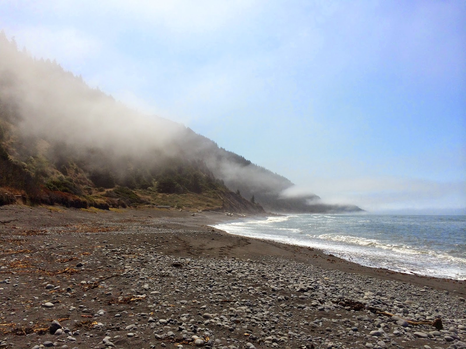
Day 5: 22 miles (mile 99.5 between Chalk Creek Trailhead and Hancock Trailhead). This is one of those days that I love, a whole lifetime in a day of hiking. This day finally felt like I was really hiking, misery punctuated with amazing moments. I wake up early, wanting to catch sunrise when I officially make it to the continental divide. This is what its all about, its beautiful and cold with my first few snow patches of the trip. My camera of course dies and with the wind whipping I don't linger. This is true divide walking and I love it. Down to the Monarch crest store which is closed and the hours aren't posted. Walking in a wet cloud for the last hour plus I am freezing cold now that I've stopped moving and was counting on this store for water (16 mile dry stretch). I huddle into a ball and hope they open at 8am, only 15 minutes away. I stubbornly don't put on more layers because I foolishly believe the sun might appear. I call home because I miraculously have service and shiver as my lips turn purple. Luckily they open, I get snacks and a warm sandwich, glorious. Then its up and over the ski resort and my first real high elevation divide hiking. I love it but worry about afternoon lightning this high above treeline. So beautiful and satisfying to climb, then down past lakes and thunder cracks. Its barely noon and suddenly I am again being pelted with hail, at least I'm below 12000 ft. I have a little pity party and trudge through the rain for a few miles. I cross a river and stare, two trails no marker. I walk in circles and eventually take the road only to see a trail sign a few minutes later where the trail I had stared at before hits the road. I debate, the road must be the old CDT, the trail the new. I follow the trail, a mile later the new trail 100% disappears in a rock field. I'm frustrated and bushwhack back to the road. Clearly the trail is not done, road walk it is. I've heard many complaints about trails stopping like this on the CDT, the risk of hiking a trail that is still very much in progress. Its early when I reach the middle fork of the Arkansas River. I should stop here, I have to cross Chalk Pass to continue and its afternoon with potential storms but it hasn't rained in at least 2 hrs and I'm antsy. I risk it, meeting some south bounders as I head up (they warn me of a tricky intersection up ahead, something I should have listened more closely to about the new miles of trail completed this summer). I feel validated, at least others made the same risky choice this afternoon. I am in love with my view, pikas squeak and the mountains are amazing. Chalk Pass is a favorite. I clear the top and look into black thunderheads, uh oh. I book it down as fast as I can. I start to hear thunder and pick up speed and the sky opens. I'm not truly at tree line yet, mostly brush at hip level spreads out around a lake. I see lightning and dive under a bush curling into the fetal position and chucking my poles far from me and hoping by becoming small in a sea of scrub brush I'll be okay. It rains for ages, I count seconds between thunder and lightning. I've heard more than 30 is when you shouldn't be out in the open. The first strike is maybe 10 seconds, but then its consistently less than 2-3 seconds. I wedge myself deeper into the bush and laugh. Why is it that this is the first moment I am 100% happy? It gets cold, my rain gear saturated I pray for an end. Its been at least and hour and still rainy but the thunder seems farther off and I debate hypothermia and death by lightning. I head down the muddy trail 100% drenched. The Chalk Creek trail head has no bathroom like I'd hoped, its a muddy circle in the grass but soon enough I find a beautiful spot a little ways down the fire road and have my home for the night.

Day 6: 28.5 miles (around mile 21.5 in the CT data book collegiate west section, by Texas lakes)
Only a short ways down the road to the Hancock trailhead. Then it's a beautiful bit of trail on an old railway line, up to a pass populated with overly curious marmots and sweeping views. A great morning only dampened by the looming clouds. Then it's thunder and lightning at 8:30 in the morning. 12000 ft just never seems safe on this trail. I'm grumpy as I cut down to the North Fork of Chalk Creek, tired and wet and sick of being lightning bait. I end up taking a break with a CDT hiker and section hiker, attempting to dry gear in the first patch of sun all morning. It's nice to talk trail and moan about the weather. When I cut across the parking lot I see a trail and a road, both potentially CDT. The trail very clearly says it's not done, and a guy mentions he's a trail crew member and while the trail is done it's not officially approved yet, but he thinks some hikers have made it through without issue. Burnt from my experience with nonexistent trail I opt for the road. I fly up the road, passing other hikers and waving to the millions of ATVs. It's fun and the view is great as I climb, at Tincup Pass I revel in the mountains and I'm content as I head down. A little ways down I happen to check my gps, and shit I am very much not on the trail. Turns out this is part of the old trail and I have missed the 20 something mile new section and am on the wrong side of a giant ridge line. Approved or not my guide had wanted me on that other trail. I am beyond frustrated with myself, my gps and the app I use only have the new section and my maps leave something to be desired with their fuzzy lines and no acknowledgement of the old trail. I look at the data book and figure screw it, I'm not going back over 5 miles up and down passes. So semi mapless and grumpy I continue on. Past more unsigned intersections and roads that aren't on my map. The rain comes and goes, past Mirror Lake and a zillion ATVs I find the Garden Basin Trailhead and grin like an idiot at the dirt bikers because there is a trail and a glorious sign that says CDT, so glad they don't take those things down! I'm warned of snow but figure I won't go far. I head onto the Timberline trail and make my way up. I miss a creek crossing somehow and realize I've gone farther than I intended. It's early enough if I pretend thunder and lightning don't exist. But the Timberline trail is true to its name and small trees line the dirt road. I cautiously head up to the ridge line and enjoy my views. The trail cuts me across a ridge line and I get to an intersection where my data book tells me to stay straight. The data book is written for the south bounder which has had me frustrated enough but this takes the cake. I sit there cursing my map because I'm just not sure. See straight is not an option, hard left or hard right I have, straight not so much. I suck it up, use my head and pick right. I continue on, and on and on. 2 miles to Sanford creek which I had heard might be hard to cross. Its easy and I take a long amazing break. I'm relieved that I'm where I'm supposed to be and the slick rocky trail has me tired. Luckily I seem to have missed the afternoon storm, hail is on the ground but other than hiking in a giant mud pit speckled with sparkly rocks for the last mile I'm dry. I gorge on sugar and continue on finally feeling better. I had crashed mentally and physically but had been to stubborn to admit it, something I need to work on for sure. I'm happy for awhile but soon enough the rest of my evening has me frustrated, more poorly marked intersections and nonexistent features the data book uses as markers amidst pouring rain and hail. Yup that creek crossing didn't happen and so on. My shoes pour water with every step. The creek I decide to stop at in the data book has no camping so I decide to dry camp. I fill my bottles and finally find a spot. Sunset is beautiful and as I set my tent up it starts to rain, but of course how could I have doubted?

Day 7: 28ish miles (approx mile 152, campsite before Hope Pass)
As I skirt the two Texas Lakes I see a moose grazing in the 2nd lake, I'm not sure who is more startled between the two of us but it makes my morning. It takes me a few miles before I realize I have confused myself and already crossed a creek I've been looking for (do not underestimate reading mileage and data backwards, man it gets confusing) One foot is drenched when I try to gracefully leap across a creek. Oh well my feet are wet, what else is new? And then 7 or 8 miles into my morning I come to the glorious sign that tells me I have made it back to the official CDT. Also at this intersection is a very long sign explaining the new route, how its open and passable etc, although turns out its not actually yet approved by the higher ups (BLM or forest service or some such) either way that sign sure would have been appreciated on the other end. Either way I head up the trail happy I made it with only cursing about every other intersection over the last two days. Over the next 5 miles I head back into the Collegiate Peaks Wilderness and climb, finally topping out at Lake Ann Pass. I've been eyeing it for ages, a huge group is on their way down and the the little procession line of arms waving and shouting has made it easy to see where I'm headed. And its beautiful, I mean drop dead gorgeous love my life so very much kind of morning time. Across a very small patch of snow I head down towards Lake Ann, stopping every few minutes to revel in the view. Day hikers laugh and chat while I'm stopped a mile or so later yard saling all my gear (every item I own is spread out to dry in the sun). I can't believe its sunny even for 10 minutes and I take advantage. This section of trail deserves to be on a highlights list, I understand why people speak so highly of the Collegiates. The new trail skips the ghost town of Winfield but I can see it across the creek, I can't get enough of this section. The mountains loom and the clouds threaten bout I stay dry gaping at my surroundings and loving the new trail towards Hope Pass. Congratulations trail builders you deserve extra points for this section. Afternoon rolls on and I decide to head up as close to Hope Pass as I can. I'd heard this is part of the Leadville 100 course and as I haul myself up the mountain I can't imagine running this thing. I'm loving the hike, it is surreally steep. I pour sweat and grin. I am so happy. Beautiful water and steep trail, I pass a campsite but just want to keep going. I finally stop when I find a campsite less than a mile from the top. I want to savor my view and am pretty sure there will be no more campsites closer to the summit. My last campsite is dry and over 11000 ft. I am in heaven, sunset is spectacular and I go to sleep dry. My very first day without rain, although if you count the fact that it rained until almost 4 am I guess not quite. Either way my feet are dry!

Day 8: 9.5 miles
Up and over Hope Pass, I'm glad I stopped where I did last night. I like the view from the top but my campsite was pretty darn great. Down and down the trail goes, ultra runners start passing me heading the opposite way and I wind my way down along a roaring creek. Old prospectors cabins peek from the forest and I get lost in imagining what it would be trying to scrape a living out of this area. I lose my sunglasses, get a little lost and feel like I'm close to the home stretch. The trail is flat and I'm skirting a large pretty valley. I pass Interlaken, an old restored ghost town that was a rich folks vacation resort back in the 1880's. Mostly I just giggle as I repeat Interlaken over and over in my head using different accents. Perhaps 8 days is long enough with my own thoughts, Ive tried to explain how talking to yourself doesn't seem as crazy when you're hiking every day but I'm pretty sure most of my coworkers just think I'm a little nuts. At least its always said fondly. Then I'm at Twin Lakes, skirting the edge I pass the intersection of the CDT and Collegiate loop, the official trail start to my trip. 160 miles done! 1.5 miles more and I'm back to my car, sandals and air conditioning and without any fuss my trip is over.

I have no idea why this trip was hard for me to enjoy. It wasn't until day 5 hiding under a bush with thunder and lightning crackling overhead just seconds apart that I thought, well hey this is fun. Really? it takes extreme suffering for me to be happy.
I honestly expected Colorado to steal my heart, when I came home from Mt Rainier all I could think about was how much I wanted to go back, and I got poured on there for a chunk of my trip. Colorado, I'm a little more hesitant about. The Continental Divide Trail has a motto, Embrace the Brutality. Well I have a feeling that trail has more than its fair share of hard times awaiting me but there will be high points to. I haven't written off my grand plans yet, but I'm certainly not underestimating how tough the CDT will be when I do finally get out there.
My gear took a beating on this trip, I use my gear pretty faithfully and my beloved sleeping bag liner literally disintegrated into pieces. I lost things, ripped things and generally seemed a bit scattered. My food that was so delicious day one way was less appealing by the end, I was hungry but everything was either too sweet or too salty. How rare to crave bland things! Deep down I know I enjoy pushing myself and this trip was no exception, not what I expected by any means but no regrets and I look forward to getting back with a different perspective.

Friday, August 8, 2014

The Collegiate Loop Part 1 (Very very delayed)

So this is a little overdue but I thought I'd at least write something. I know how much I enjoy looking at trip reports and armchair traveling my way through less exciting times in my own life. The only problem is this trip ended more on a frustrated whimper for me than anything else. My last day actually started off great, I slept in, miraculously had dry feet and I slept above 11000 feet. What more could I want? I trotted down the trail, pretty content with life. Out of laziness I leaned down to fill up my water without taking my pack off and promptly lost my sunglasses in the rushing creek. I frantically grabbed but between the water bottle and trekking poles away the glasses floated. Darn it, I kept those things through the whole PCT. Oh well at least it was only one morning I'd have to squint my way down the trail. About 5 minutes later I took a wrong turn, only realizing this when I was halfway across a large meadow thing on a fire road. Oops, back I went around the tree that had fallen halfway across the intersection. Soon enough the trail was done and I hit the road. Anticlimactic as usual. When I pulled off the road to get some gas in Green River Utah I made my most impressive mistake of the day. No pockets and sleep deprivation had me placing my phone on my roof while getting gas and then driving away. 75 mph on the highway and 2 exits away I realized my mistake.

I drove back and some very nice truckers and gas station attendants helped me, attempting the find my phone app and walking up and down the highway with no luck in a not so funny comedy of errors. Word to the wise, if your phone is on airplane mode (like you might do to preserve battery life on a long backpacking trip...) find my phone is a fail, as is the cloud and its magical storage. So in one fell swoop I lost all my photos and my phone. I was startlingly upset over the loss of my photos, after all I know I hiked, I know I will remember the views and the miles. I feel shallow and annoyed at myself but nevertheless it bothers me.

The trip overall was about 160 miles and I completed the loop in 8 days starting on 7/11. I started at Twin Lakes in CO. Finding the trail head was a little tricky and I hit the trail around 5pm in the pouring rain. I finished the loop in the early morning with thankfully no rain and a much simpler time finding my way back to the road. The mileages are based mostly on the GPS app by Guthook but also the Colorado Trail datebook. Overall I don't regret this trip at all but I found that it took me awhile to get into it and actually enjoy myself, coupled with the lack of photos blogging in depth about it sounds pretty unappealing so a shorter summary it is.

Day 1: about 9.5 miles (to Clear Creek campground). More time on dirt roads and under power lines than expected, but a great rainbow as I headed down to the pretty campground with a surprising amount of civilization and people at the campground. My hike was bouts of pouring rain, green aspen, glimpses of mountains and hellacious mosquitoes at my campsite. I tucked myself into bed excited for the upcoming miles.

Day 2: 21.4 miles (to mile 29.7, top of ridge near Mt Yale). Aspen, creeks, and wet feet was the theme of my day. I woke up chilly with soaked shoes and a few short hours after they dried it was back to pouring rain and thunder storms. By afternoon I would see a few tents tucked into trees but no one else silly enough to hike in the pouring rain. Pretty trail overall, I spent a few hours killing time under a big tree sheltered from the rain near a parking lot and a bathroom, classy to a T. I climbed up to the ridge after 5 hoping to avoid afternoon thunderstorms. Gloriously steep, but ridiculously wet my plan failed. The hike was probably not the wisest decision as the skies opened up minutes after I set out, oh well I had fun. My campsite seemed clever until the trees continued to rain on me long after the rain stopped (sometime around 10 pm).

Day 3: 26 miles (to mile 55.7 Little Brown's Creek). I was already ahead of schedule and today was Mt Princeton Hot Springs. I hoped to get there early, kill the afternoon possibly enjoying some hot springs and get my resupply package. The start of my morning was beautiful and soon enough I was heading down, mountain bikes made way to dirt roads, atvs and dirt bikes. This trail is not what I expected, I was constantly surprised I was still going the right direction. Then I was at the resort before 1 pm, just like I hoped. It was a huge and overwhelming world of watersides and tourists spreading well over two city blocks. I couldn't handle it. I resupplied on the lawn, and when it started raining I retreated into the restaurant and after a lackluster meal I headed back to the trail, 6 days of food was heavy! I chatted with some Colorado Trail thru hikers and then found myself alone again. At least I felt validated, they had booked it early too, simply too much humanity. Chalk cliffs are pretty and the meadows were gorgeous but large open meadows with afternoon lightning didn't seem like my brightest idea. I stopped and camped while it was still light and for the first time this trip went to sleep in the pattering rain happily knowing at least my shoes were going to start the morning dry.

Day 4: 22 miles (last creek crossing before the official Collegiate loop intersection approx mile 77.5)
Past zipped up tents and sleeping campers, a mellow morning. I pass the Mt Shavano trailhead and its requisite day hikers. Bagging 14000 ft peaks sure is super popular out here. Then down past a trailhead and bathrooms and climbing again. I pass the top of the ridge without realizing it, only stopping to enjoy a small sliver of sunshine as the clouds relentlessly continue to cover the sky. Soon enough I've made it to US Highway 50. I love actually having a connection to something on this trail. Then thinking I'm lost I search for the trail, nope more road walking. Pavement makes way to dirt as I pass the disappointing Foose Lake, more of a small fishing pond crowded with anglers. Thens its up and up I go, unmarked dirt roads finally make way to trail and just when I think I'm in the clear and almost to my possible campsite the sky opens up. Hail, so very much hail, pelting me and then its rain soaking to the skin. I take a break during a short lull and decide to press on on. Guthook says I'm at the last water but the CT data book says theres another spot around 3 miles ahead. If I camp there I'll get to the true Continental Divide less than .5 miles into my morning and split with the Colorado trail. No more southbound, it will be looping back north on the CDT back to Twin Lakes. I press on, more pouring rain but water overnight will not be my issue. So much water, the trail itself is a creek most of the time. Guthook definitely has had some missteps water source wise so far. But its pretty and other than a lack of campsites on the steep mountainside its not bad. I finally find a spot near a little waterfall and peel off my wet things. Tomorrow is the CDT!


By the way I'm pretty sure this trip report was not meant to be, sorry if its disjointed but I've lost the silly thing twice and rewriting it is getting old.