Thursday, April 30, 2015

Day 7: CDT, PCT style

4/29
Day 7: mile 106.9-130.1 total miles, I'm honestly not sure maybe 26? But officially 23.2)

This post is long but a whole lot somehow happens even when you're just walking all day. 

Today was pretty great. I think I have Thatch to thank for that. Moods are contagious and he was so happy last night that it definitely rubbed off. 

I woke up to a chilly morning and my sleeping bag covered in frost yet again, oh well at least stuff dries out here super quick. I packed up and headed out. The only water until Silver City was 15 miles away and I've decided to add at least an hour to my planned hiking everyday assuming I'll get misplaced from the trail so time was a wasting. 

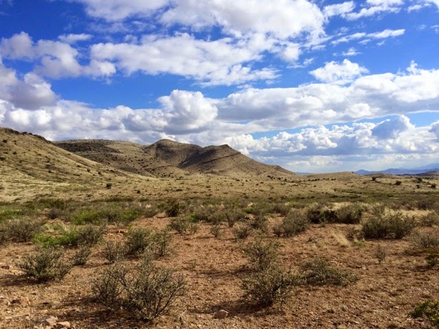
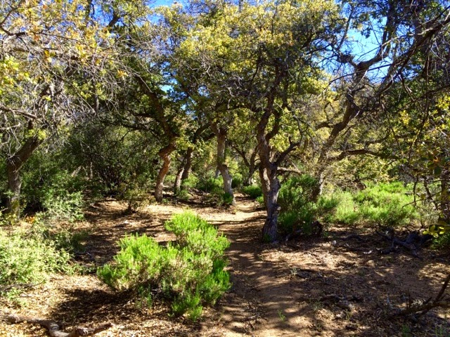
The morning was great, cruising up and down the trail I felt like I was back in the East Bay, it almost looked like oak woodlands except for the occasional cactus. It was so beautiful with the ever increasing trees and the gentle climbing brought some pretty decent views. 


I came to the Burro Peak trailhead and found my first official trail sign which was cool. 


And then I started climbing, I stopped and checked my maps and then the elevation profile I had. I had this vague memory of no climbing the first 200 miles. Nope, way wrong. I was in for over 2000 feet of gain, up over 8000 ft. Which for a frame of reference is about where Mammoth is (South Lake Tahoe is only 6 something). But man was it fun. That was my first big climb in awhile and it was hard but great. The first peak had these cool old ruins and the second felt just like Tahoe. Very trippy. I made it to the top faster than expected and met Porscha and JW (I think those were there names). Chatted and then headed 2 miles down to the water source. 


Muddy spring wasn't bad, my first official natural source on the trail, and nice and cold. I killed a few hours with the other two hikers and Rafiki showed up. I expected Banana Pants and Thatch but either way we'll all be in town tomorrow. 


The big debate was which way to go. The maps literally had this section marked as confusing intersection and said just head down the canyon and ignore the  new signs because the trail would dead end. But in Lordsburg we had been told the trail was finished. Plus the number of trails and signs in real life and on the map didn't match. 

The couple took one way and I headed the other. I of course lost the trail about a mile in. But everything sort of clicked and I had no trouble figuring out where I needed to be. I was having a great time and found a real live stream and slid under some barbed wire only to realize I was on actual private property. I high tailed it out right quick, you know what makes for great stealth trespassing, not my neon backpack. Quick enough I popped out and found myself right in front of a CDT sign, awesome! 


And then Tyrone Rd which was exactly where I meant to be. Only I didn't check my GPS and just blithely followed the signs. I thought something was off but I didn't investigate. When I did finally check the GPS I was 1.6 miles off trail. But how was that possible, I was staring at a CDT sign? So this is actually a new section of trail that just opened this week that I don't have the maps or mileage for. We had talked about it in Lordsburg but I couldn't remember, it was either 2 or 13 miles longer than the trail I had meant to take. I acted a little rashly and instead of just turning around I headed down a road that wasn't even on my map. I was thinking was roads are easier than bush whacking down canyons and this way I could try to cut back to Tyrone Rd. And so I headed down into what was officially called Mystery Canyon, with the biggest mystery being what the heck my plan was. Needless to say I eventually ditched the road and bushwhacked my way up and over 2 smaller ridges and then up a creek to connect to another road that eventually lead to Tyrone Rd. And so after 2.5 hours I had officially gone about half a mile. Whoops. Honestly I actually had a lot of fun. I saw an only abandoned mine and a mini waterfall, beautiful trees and most importantly while I wasn't where I want to be I never felt truly lost. I'm slowly getting the hang of this finding your way back to the trail thing. Now I just have to work on not losing it in the first place. 


Tomorrow is Silver City. I had originally thought to spend the night or maybe even take a whole day off if I felt like it but it turns out this weekend is some giant bike race. I believe Tour of the Gila?  Either way it sounds like rooms are super hard to come by. So unless someone who called ahead wants to share I'll probably just walk a mile out of town. My stop after Silver City is only about 50 miles further and had a resort with hot springs which is sounding like a way nicer option anyhow. 


Now to sleep. I have a little bit to the highway and then 12.5 miles walking next to highway 90 to get to town. 

Day 6: the Forest! Well sort of

4/28 
Day 6: mile 84.5-106.9 (22.4 miles)

Today I felt a little cranky and off all day. I think it was mostly due to too little sleep which just made everything just that much harder and me even crankier. 

The day started with breakfast at the motel, and talking with the people getting ready to leave on today's shuttle which was fun. Thatch had to go to the post office to mail his resupplies and I hate hiking in afternoon heat so I took off. It looks like everyone at the hotel was planning on taking off at some point today so this section might be crowded. 

The trail heads straight down Main St through Lordsburg. 


Then the even more scenic highway 70 for 2 miles. Finally turning off highway 90 and heading cross country. 


This was the start of my trouble. First you slide under the barbed wire, no problem. Then do you see the short dark marker next to the bush on the far right of the sign? Yeah nice and obvious huh. I was about to spend 10 miles in blasting cold wind walking across this nonsense. 


I of course ended up way too far south a mile below the "trail" and found my way back to the route walking under a telephone wire track. Very glamorous. 


See the posts? Yeah I certainly didn't. On the bright side most people I talked to in the afternoon didn't either. 


This faint trail saved my sanity. This mostly took me the last 5 miles of cross country. I guess it was the lighting because whenever you turned around the signs were simple to find. 


And then I turned through a beautiful metal gate that meant no more cross country. The trail became a 2 track 4WD road and I officially entered the Gila National Forest. So far it's been all BLM land. It was awesome. The road started climbing and trees were regularly all around. 


Then it was time to play goldilocks with my water sources. Stealthily trying to find water while the cows were away. 


Not too hot or too cold, just not there. 


Way too tricky to get, plus empty too...


And finally just right! There was a pipe dripping into the actual tank so I didn't have to drink cow snot or anything. Plus Hot Springs and Rafiki were there so I killed a fun few hours. Rafiki left but Banana Pants arrived so the hours passed surprisingly quickly. I had been in a great mood since starting the road walk and the long break helped. I had been so frazzled earlier in the day I didn't take any real breaks. 

After leaving Engineer Windmill I officially passed the 100 mile mark. Woohoo, someone even drew this in the dirt. 


It was actually starting to feel a little more like mountains, those roads actually do a fair bit of climbing and it was really fun. 

Then just 3 miles later was Co-op windmill. The nicest one yet! It's funny everyone I've seen today is intentionally hiking solo but likes to be social at campsites and water sources. So you get the freedom during the day but still get to interact with hikers. 


More rolling hills and some climbs and then the most magical thing, official trail. Not roads, or signpost to signpost or weird rock posts but 100 miles + into this thing genuine trail! Steep as all heck but awesome. 


I hiked another hour or so and my foot started hurting for the first time on the whole trip and I started to get all fatalistic thinking this is the end of my hike (dramatic aren't I). I dragged myself a little farther until I found a campsite and tried stretching my foot and calves. Mostly just moping around. And then magically Thatch showed up and he was ridiculously happy, he'd had a great day. So instead of getting bogged down and just going I'm going to make sure I take breaks tomorrow and go a bit slower. We'll see 

Tuesday, April 28, 2015

Day 5: Town Day

4/27
Day 5: mile 78-84.5 (6.5 miles)

I wasn't in any particular hurry since I had so few miles until town but I woke up at 6 and figured I would head out since I was awake. 
Staying in town today has been a real debate for me. I'm trying to be less hard on myself and stop comparing myself to other hikers, rather just do what feels right at the time. And a long town day sounds great. I regret how few towns I actually stayed the night in and explored. Town days are filled with chores, catching up on real life (bills, emails etc) and most importantly food for the next section, sorting gear, replacing bad gear and sometimes making up resupply boxes for farther ahead in the trail. Most post offices and resorts/hiker trail Angels will hold boxes 30 days which works great for hikers. 

Buildings...

It was a quick morning, rolling sign to sign over rocky tread and finally a road walk down Main St and hiker central in Lordsburg, the Econolodge. And there was Thatch in his bright orange wind pants walking towards me! Turns out he pulled into the cache right at dark and slept on the other side of the fence. He left before me trying to catch Hanitizer to pay him back, missed him by a few minutes. But we killed the morning chatting up all the hikers at the motel, drying all of our gear and even got a room early when one of the cleaning ladies felt sorry for us. 

Town breakfast (and lunch)

Yard sale. It didn't rain last night but I woke up soaked covered in frost 

Prewash socks before real laundry, they get cleaner that way. 

Thatch had to resupply for 12 days, this next stretch and 2 full resupply boxes. His entire pack was food in the way back from the store. 

Easiest hitch ever. Some guy pulled over offering us a ride back to hotel, we hadn't even been trying. 

The rest of the day disappeared in an instant of showers, resupply and do many other chores. Tomorrow it's breakfast and then 58.6 miles to Silver City. Should be good. 


Day 4: and then it rained

4/26
Day 4: mile 59.9-78 (18.1 miles)

Today was a great reminder that this is not the PCT. 18 miles to water or 25 miles to town, it should have been a cakewalk with the hardest decision to push to town or not. Not so much. 

I'm not sure if Thatch or the rain woke me up. Either way at 5:15 it was sprinkling. I popped open my umbrella curled into a little ball and pretended nothing was happening. The rain stopped but by 5:45 was at it again so I packed up and headed into the predawn light. Thatch was already gone and within minutes the wind was whipping into my face and it was pouring. I couldn't see a trail sign to save my life and all the landmarks to navigate towards had disappeared into a gray wall. I kept walking, under so many barbed wire fences through flat cattle land. By 8 my hands were no longer working well and I couldn't get them to function with my gps. Plus I was starting to full on teeth chatter kind of shiver. I had made it to Mayfield Rd which the trail crossed but I just couldn't figure out where. I bee lined to the best trees/shelter I could find and got my tent up in the wind. Ever try putting stakes in solid mud with cold hands and not a rock in sight? Yeah that's a challenge. But it was up and I was in, warm sleeping bag, warm socks and some peanut butter. Back on track. 


The wind and rain kept up for awhile and I slept on and off. Using my umbrella in my tent to prop it up when a stake came out, I was not moving from that sleeping bag. Finally around 11 it looked like the sun might stick around. I finally ate some more, packed up my wet and filthy gear the best I could and headed out. 

My pathetically sheltered spot

I headed off and was ridiculously happy when I found my first sign. 


Less happy when I realized during the storm I had gotten 100% turned around and had actually been heading south, I was almost back to where I had started. Back heading North I felt good, until I again stubbornly went too long in one direction despite not seeing any signs. I was never too far from where I should be but far enough that it was frustrating. It wasn't until almost 2 that I was truly on track again and I was a little gun shy, assuming I would get lost again at any minute. 


In all those hours I had gone less than 3 miles. I now had to get 15 miles to the water cache and it was getting late. Town was out of my reach, I was just hoping for water. So I started booking it across wide open countryside fighting some head on wind the whole way. 


I had been hoping to avoid cow water but I was low enough that I went for it. To explain there are no natural water sources these first 120 miles or so. The caches are present the first 80 but otherwise you rely on cow water. See cattle is big money and those guys have to drink too. So things like solar wells and windmills get water to thirsty cows and hikers. 
The first tank I passed was pretty rank but the next wasn't bad so I happily grabbed some slightly green algae water and off I went. 


Back on the trail still feeling great. The plus side of the crazy wind is you can sing at the top of your lungs and no one can hear you. The cows certainly don't seem to mind. 
The rain continued to spit occasionally, I even got some hail when I was wandering around 1 but thankfully nothing like the morning. 

The cross country gave way to some road walking and some really beautiful scenery near Pyramid Peak. 

Guess which ones pyramid 

Signs make me goofy now 


I made it to the cache by 6:30. No way was I trying for town. I was going to enjoy my sleep and take all of Monday to do town chores in Lordsburg. 

There are registers all along the trail which are super fun for us hikers. They are in places like water caches, trail heads and businesses hikers frequent in town. Everyone writes in them as they pass through so you get to see everyone whose ahead of you. Hanitizer of course had already headed into town, the Maine Guy must have passed during the storm and there was no sign of Thatch so I hope he's okay. I'm thinking he might have had a similar day to mine. But for me I'm cowboy camped behind a bush near the cache in a vague attempt to stay out of the wind. Tomorrow town!

Day 3: Finding my feet

4/25
Day 3: mile 36.2-59.9 (22.7 miles)

Today had a little bit of road walking and a whole lot of cross country. It's a funny way of hiking, I have to stare at my feet because of the rocky footing and the risk of stepping on rattlesnakes but I always have to glance up and all around hoping I haven't lost the marker I'm heading towards. Just because you are on a road or nice dirt path does not mean it's going where you should be going. But so far it's loads of fun. 


Made it to Cache 2 by 9 am, I was pretty low on water and happy to see new faces. 3 older retired gentleman all out hiking. They were having a pretty rough time feet wide and were planning on catching a ride back to Lordsburg to rest up. The couple with the dog I had seen the day before showed up as well. I was so happy to see that the dog looked much better today. 

It's hard to hitch when there's no traffic, find the hiker...


Then it was across Highway 9 and back to cross country through the wide desert. A fun section including a fair bit of dirt road and then back to cross country. Sometimes there's a pretty well defined footpath between signs but it likes to disappear and head of into the wrong direction so you can't depend on it. 


Around mile 50 was a little oasis at a water/tire tank. I had to take a quick break! So far stopping every 4-6 miles for a nice shoes off break has been working great. 


Oh look pretty green bushes that I have to walk through (so many times!)

Yeah these suckers have teeth, there's a reason like my legs look like they lost a battle

More cross country, and I even climbed a little pass. No great places for a break so I had to head farther than I wanted. I refused to have two days in a row with breaks in full sunlight. I muttered a bit to myself about the heat then found a perfect tree and relaxed. Stretching and yoga and a failed nap. Oh well it was still great. 


Confused sign


This area is so beautiful, I had no idea what New Mexico would be like but I've been pleasantly surprised. So far it's awesome. 


21 miles found me at the water cache before 5. I still felt great and thought maybe 2 more miles would be fun. Thatch showed up and we caught up on trail gossip and then I headed out. Beautiful but insanely windy. I finally gave up finding shelter and just ate dinner next to a spiky bush debating my plans for the next few days. Thatch reappeared and suggested sleeping in the arroyo to hide from the wind so here we are. 


Camping in an arroyo? Sure why not. 

Looking down into camp 

Cross your fingers that those rain clouds don't open up until I'm hiking tomorrow, word is thunder storms are expected.